Thursday, August 1, 2013

Mount Baldy 11,068 Feet!

Mount Baldy is a major peak (11,068 feet) that sits right between Alta and Snowbird ski resorts.  Impressive right??
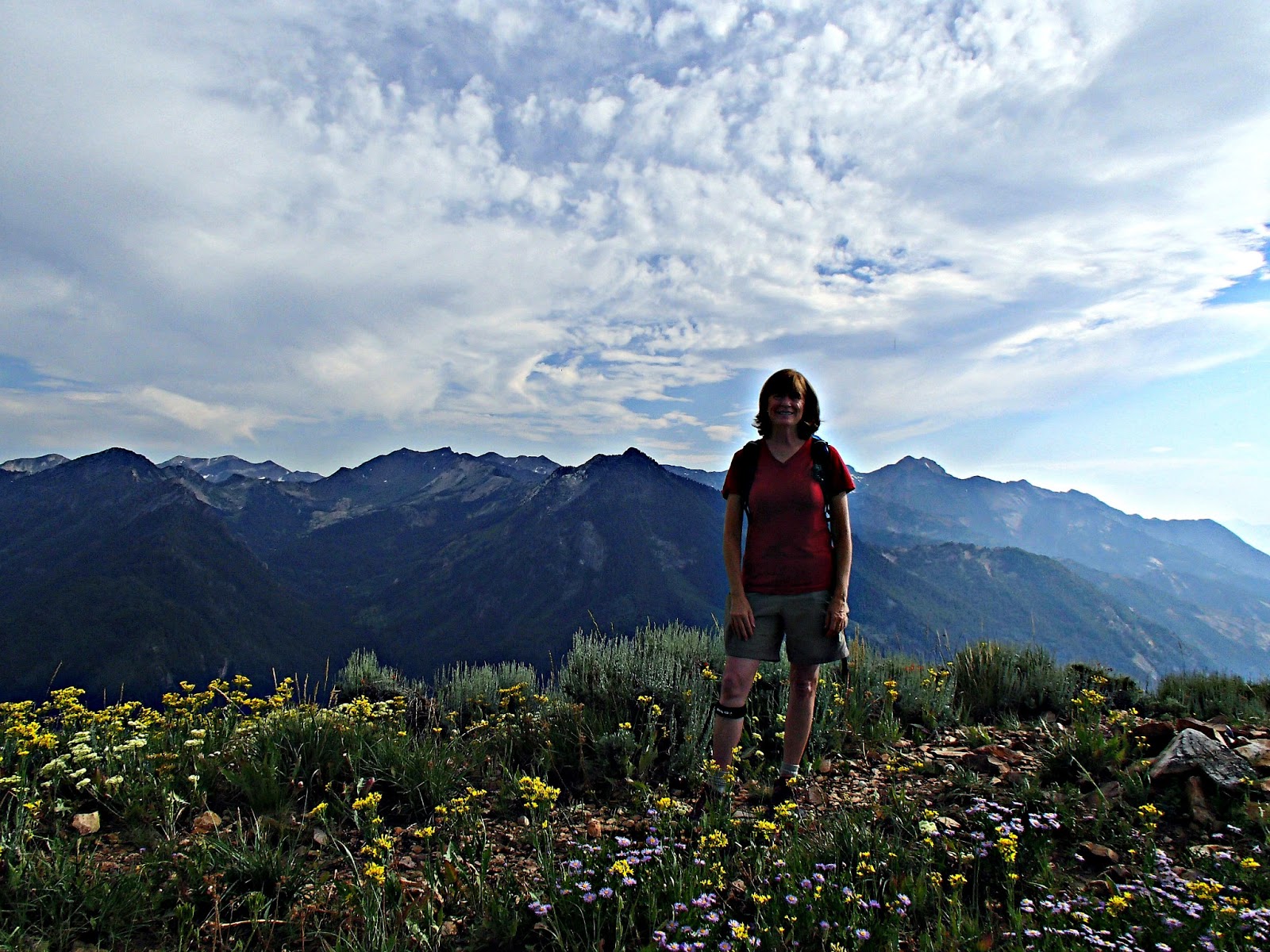
And it is a pretty cinchy climb to the summit, at least the way we climbed it.  What!!  First of all you ride the Snowbird Aerial Tram to the summit of Hidden Peak (11,000 feet) which will cost you $17 per person. There is a service road on the left of the tram that will drop you down toward the beginning of the Mount Baldy trail.  The trail looked a little intimating to me at first because the footpath follows the narrow rocky ridge along the crest, but it is a well established path and pretty easy.  Always take care, use caution and make sure of your footing as you climb.  It took us less than 45 minutes to make it to the summit of Mount Baldy. The elevation gain was only about 560 feet.  There were some amazing views in all directions.
The Snowbird Tram as it nears Hidden Peak.


 Mount Timpanogos in the far distance.
 
Another great mountain view!


On top of Mount Baldy all cover in junk!

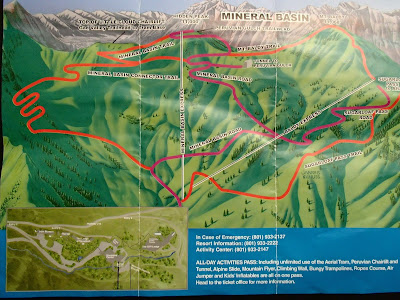
We met another hiker from South Carolina who recommended that we take the Mineral Basin Trail back to the tram which made for a really nice loop hike.  Be sure to pick up one of these Summer Hiking and Biking trail maps from the tram.  I had no idea there were this many options to hike.
The Mineral Basin trail was well marked and takes you across the mountain covered in beautiful wildflowers.  Plus you are hiking in the shade which feels great on a hot afternoon! This trail will become a yearly event for me during peak wildflower season.
 

One of the ski runs was named Lupine Loop and we could definitely see why.  The mountainside was covered with Silvery Lupines.

The hardest part of this loop trail was the fairly steep climb back up to the tram.  I have read that another possible summit from Hidden Peak is the American Fork Twin Peaks in this picture.  It looks too precarious from here!


♥♥♥♥♥♥♥♥♥♥♥♥♥♥♥♥♥♥♥♥♥

"For myself I hold no preferences
among flowers so long as they are
wild, free, spontaneous!" Ed Abbey 

 Wildflower of the Week

Silvery Lupine is the most common and widespread lupine in Utah.  They are part of the pea family and after flowering they leave a pod that looks similar to a pea pod.  The plants grow in dense colorful clumps and make for a very beautiful mountainside.


♦♦♦♦♦♦♦♦♦♦♦

Peaks Bagged

1.  Grandeur Peak ♦♦ 8299 

2.  Reynolds Peak ♦♦ 9422

3.  South Guardsman Pass Peak ♦♦ 10,420

4.  Mount Baldy ♦♦ 11,068

******Miles hiked tally     
beginning March 22, 2013

90.7

Sunday, July 28, 2013

Cardiff Fork Trail/Road


Big Cottonwood Canyon never ceases to amaze me.  There is so much beauty - yes, so much to explore - yes, and interesting history as well.  The Cardiff Fork trail is actually an old road dating back to the early 1900's that leads to an old mine site. If you do not like hiking on loose rock, this isn't the trail for you.
The Cardiff Mine was a booming operation from about 1910 until the 1950's and now all that remains are the tailings from the old mines and a huge ore bin.  The road to Cardiff Mine was closed in 1992 to motorized vehicles unless you are a private land owner.  I thought it made for an interesting hike.  The hike to the mine site begins at the Donut Falls parking area and follows the old road for 2 1/2 miles with and elevation gain of 1340 feet.
Mine Tailings
Only remaining structure is this huge ore bin.
Apparently the road continues over Cardiff Pass at the head of the canyon and will eventually drop you down into Alta.  That would be a little too much of a hike for me.
There is still a lot of private property in the area so you must stay on the road and honor posted signs.  The scenery in this canyon was really quite beautiful.

It rained on us for a good portion of the hike, but the rain was totally refreshing so I didn't mind it one bit!
Also found some interesting looking mushrooms on this hike!
Mushrooms anyone???

♥♥♥♥♥♥♥♥♥♥♥♥♥♥♥♥♥♥♥♥♥

"For myself I hold no preferences
among flowers so long as they are
wild, free, spontaneous!" Ed Abbey 

 Wildflower of the Week


This cheerful wildflower is called Rose Heath.  The buds start out bright pink and then turn into a white daisy like flower.  It tends to grow in patches throughout the drier mountain sides.  I just happened to catch a couple of butterflies napping.

♦♦♦♦♦♦♦♦♦♦♦

Peaks Bagged

1.  Grandeur Peak ♦♦ 8299 

2.  Reynolds Peak ♦♦ 9422

3.  South Guardsman Pass Peak ♦♦ 10,420

******Miles hiked tally     
beginning March 22, 2013

89.5

Friday, July 26, 2013

Peak 10,420


 Need an easy peak to climb this summer?  Up where the air is cooler?  An easy, peasy peak?  Try Peak 10,420.  This peak doesn't actually have an official name, but the "Wasatch Core 77 Peak List" calls it the "South Guardsman Pass Peak".  The trail begins on the right hand side of the parking area at the top of Guardsman Pass climbing up one half mile to the summit with an elevation gain of 930 feet.  It took us less than an hour to climb to the summit.


You are rewarded at the top of 10,420 with a really cool cairn.  A cairn /'karn/n: is a heap of stones piled up as a landmark or as a memorial.  Very photo worthy!


Also from the summit of 10,420 you have excellent views of Heber Valley to the east and Brighton resort to the west looking down on Lake Mary and Twin Lakes.
As an added bonus and because we weren't finished hiking we continued on to Lake Lackawaxen.  I love this lake!  It is secluded and very pristine.  Hope it can stay this way!


While walking around the lake we saw many of these swimming around the logs.  It is a tiger salamander!  A young one or eft/newt.  Utah is home to only one species of salamander and there it is!  They must have access to fresh water and usually stay hidden from view under logs, rocks and leaves.  Salamanders can not survive in a polluted environment.  I was lucky to get such as good picture of this one!
We also came upon this fallen tree which had to have been a 100 feet long.
And the Skunk Cabbage was in full bloom!


♥♥♥♥♥♥♥♥♥♥♥♥♥♥♥♥♥♥♥♥♥

"For myself I hold no preferences
among flowers so long as they are
wild, free, spontaneous!" Ed Abbey 

 Wildflower of the Week

These are the blossoms from the skunk cabbage plant.  Skunk Cabbage grow in large patches in subalpine meadows.  The leaves of this plant are really large, easy to recognize and will grow right through a snow bank in spring.  The flowers are lily-like and tower over all other plants.

♦♦♦♦♦♦♦♦♦♦♦

Peaks Bagged

1.  Grandeur Peak ♦♦ 8299 

2.  Reynolds Peak ♦♦ 9422

3.  South Guardsman Pass Peak ♦♦ 10,420

******Miles hiked tally     
beginning March 22, 2013

84.6

Thursday, July 18, 2013

Lovely Lake Catherine

View of Lake Catherine from Catherine's Pass
Lovely, lovely Lake Catherine!  The hike to Catherine's Pass and on down to Lake Catherine from Albion Basin is one of my all time favorite hikes.  This is one of the best hiking experiences we have in our Wasatch Mountains (my opinion of course) especially during peak wildflower season from mid or late July through mid August.  The main trail to Lake Catherine begins from the parking area at the top of Albion Basin Road just before you reach the Albion Basin campground.  It is 1.25 miles to reach Catherine Pass with an elevation gain of 800 feet.  Add another quarter mile to hike down to the lake.  I highly recommend that you take the time to hike all the way around this lovely lake which adds a half mile to the hike.  Total distance roundtrip becomes 3.5 miles.
Views of Lake Catherine from four directions.
Another reason to love Lake Catherine is the wildlife.  There are almost always moose to be found hanging around the lake.  Today along with a moose we saw a sage hen and the resident chipmunks.


More of the moose!

Sage hen or grouse?

Alvin??
And did I mention Wildflowers??  You really need to see these for yourself because photos just can't capture how beautiful this area is!


Meadow of Elephantheads.


More Photos in case you haven't seen enough already :)


From Catherine Pass you also have the option to climb Sunset Peak which was our plan for today.  But there were thunderstorms in the distance and the sky was a little too ominous to be climbing peaks -- we thought it best to be prudent and save peak bagging for another day.
Sunset Peak elevation 10,648

♥♥♥♥♥♥♥♥♥♥♥♥♥♥♥♥♥♥♥♥♥

"For myself I hold no preferences
among flowers so long as they are
wild, free, spontaneous!" Ed Abbey 

 Wildflower of the Week


If you take a really close look at this wildflower you can see where it gets it's name.  It has a long trunk and big floppy ears just like an elephant hence the name Elephantheads.  Look for these bright magenta flowers in wet meadows and along mountain streams.

 ********************************

Peaks Bagged

1.  Grandeur Peak ♦♦ 8299 

2.  Reynolds Peak ♦♦ 9422

******Miles hiked log     
beginning March 22, 2013

84.6


Thursday, July 11, 2013

Reynolds Peak

High on the mountain top!
Summer is already half over and I finally just climbed my second mountain peak of the year.  Reynolds Peak elevation 9422 feet! (BIG HIGH FIVE!)  We started our climb at the top of Millcreek Canyon on the Big Water Trail towards Dog Lake.  The Big Water Trail begins at the Southwest corner of the upper parking area.  It is a nice gradual trail with many switchbacks and a couple of stream crossings.  Big Water and Little Water trails are extremely popular mountain bike trails and mountain bikes are allowed on the trails on even numbered days.  We hiked on July 10 so we had to dodge several bikes. (I'm sure the bikers are equally annoyed to have to share the trail with hikers) Dogs are allowed in Millcreek Canyon and must be on leash on even numbered days, but no leash is required on odd days.   The trail to Dog Lake is well established and easy to follow, but the trail to Reynolds Peak was a little confusing.  We came to this junction and followed the Mt Olympus Wilderness trail. OOPS!  It was a major trail, but the wrong way.  So when you reach this sign continue a few hundred feet towards Dog Lake and you will find the trail again on your right to the summit of Reynolds Peak. We did discover the the Mt. Olympus Wilderness leads to trails for Butler Fork and Mill D in Big Cottonwood Canyon.  It would be interesting to hike from one canyon to the next but be sure to have a car waiting.

Reynolds Peak

9422

The hike to Reynolds Peak took a total of 3 and 1/2 hours.  It was 5.5 miles with an elevation gain of 1822 feet.
We have our goal in sight!  At the top you are surrounded by mountain peaks in all directions.  To the east and south is Clayton Peak, American Fork Twin Peaks, Devils Castle and Kessler Peak.  To the west and north is Dromedary, Broads Fork Twin Peaks, Mt. Raymond and Gobblers Knob.  It is simply incredible!  And the wildflowers were gorgeous!


At the very top you will find a makeshift mail box.
  More photos!


The only downside to our hike yesterday was the bugs! They were bad!!  And they were biting flys more than mosquitos.  I have been using "Burt's Bees" all natural herbal insect repellent but it did not deter the pesky flys.  I guess it is time to try a new product.

♥♥♥♥♥♥♥♥♥♥♥♥♥♥♥♥♥♥♥♥♥

"For myself I hold no preferences
among flowers so long as they are
wild, free, spontaneous!" Ed Abbey 

 Wildflower of the Week

This type of paintbrush is called a split-leaf or rhexia-leaf.  It is very common in all mountain meadows from June through August and comes in a variety of colors.  The split-leaf paintbrush is one of several different kinds of paintbrush in Utah.


Peaks Bagged

1.  Grandeur Peak ♦♦ 8299 

2.  Reynolds Peak ♦♦ 9422

******Miles hiked tally     
beginning March 22, 2013

81.1