Wednesday, November 13, 2013

Observation Point @ Zion NP

Observation Point looking down on Angels Landing
My absolute favorite time to visit Zion National Park is in autumn.  The golden colors of fall makes this exquisite place even more beautiful!  I have hiked many of the trails throughout the park and was looking for something a bit different on this trip.  We decided to try the East Mesa trail to Observation Point then return by way of Echo Canyon and the Weeping Rock trail.  A shuttle car is necessary for the way we chose to do the hike or you may be able to contact one of the Zion Park adventure companies to see if they offer rides out to East Mesa.  It was a little tricky finding the East Mesa trail and I'm going to do my best to give directions.  Begin by driving to the east entrance of the park along the Zion - Mount Carmel Highway.  I love this stretch of road.  It's fun to drive through the 1.1 mile tunnel and if you are lucky you will spot a herd of big horn sheep that hang out in the area around Checkerboard Mesa.

From the east boundary of Zion drive about 2 miles on Route 9 until you reach a sign for North Fork Road, turn left and drive this paved road for about 5.5 miles until you reach Zion Ponderosa Resort.  Turn left into the Resort passing under the gate for Zion Ponderosa.  Follow Pine Angle Road heading west, here the paved road ends and you start passing privately owned cabin lots.  There were two or three signs along the road pointing you in the direction of Observation Point.  The road becomes really rough the last couple of miles. (Not recommended for low clearance vehicles, but my Subaru Outback did great)  The drive from Springdale to the East Mesa trail took us about one hour.  The dirt road will end at a fenced area, find a place to park and the East Mesa trailhead is just a few feet left of this fence.  The East Mesa trail follows an old jeep road through beautiful ponderosa pines with some great canyon views as well. 

It is a leisurely walk of 3.2 miles to reach Observation Point.  From Observation Point the views of Zion Canyon are truly spectacular!  Spend some time at the top just to soak in the views.

Standing on the edge!

We hiked down from Observation Point through Echo Canyon along the Weeping Rock trail.  This is a 4 mile trek down a steep trail (2148 feet of elevation change) with long drop-offs, but this trail is classic Zion National Park scenery and so worth doing.


Echo Canyon

More of Echo Canyon

Beautiful golden colors in the canyon

At the bottom of Weeping Rock trail we caught the Zion Park shuttle for a ride back to the visitors center where we left our second car.  The only downside of doing this hike from East Mesa Trail was driving back to the beginning of our adventure to get the Subaru.

♥♥♥♥♥♥♥♥♥♥♥♥♥♥♥♥♥♥♥


******Miles hiked tally
beginning March 22, 2013

184.5


Thursday, November 7, 2013

Lake Solitude Snowshoe

I really love to snowshoe!  Not only is it fantastic exercise, but snowshoeing makes the winter season so much more bearable.  When the winter inversion socks in the valley, the mountains have clean, fresh air to breathe.  Snowshoeing is an inexpensive sport.  Once you purchase your snowshoes you are set. (No costly ski lift tickets required!)  Check out Costco this time of year for great deals on snowshoe sets.  I purchased my snowshoes from Kirkhams Outdoor Products last year at the end of the season and got them for 65 percent off.  And I love them!!  Check out this website for great snowshoeing tips and trail descriptions.  www.snowshoeutah.com

Yesterday was my first bona fide snowshoe hike of the season.  Too early for really great snow depth, but it was still beautiful and a lot of fun.


Lake Solitude

We wanted to try the trail to Lake Solitude for snowshoeing before the Solitude Ski Resort opened for business and we thought there would be plenty of snow at the top of Big Cottonwood Canyon. The trail to Lake Solitude begins by hiking around the north side of Silver Lake which will soon become Solitude Nordic Center. When the Nordic Center opens in a few weeks an all day snowshoe pass is only $5.  The total distance to Lake Solitude is just over 3 miles roundtrip with an elevation gain of only 300 feet.
On this hike you will pass across about three ski runs which will make it a tricky snowshoe when the skiers are on the mountain.

We extended our hike a bit by walking all the way around the lake. I know I've said this before, but it is fun to see the mountain lake from all directions and make the hike a bit more challenging.


Duck walking on thin ice!
♥♥♥♥♥♥♥♥♥♥♥♥♥♥♥♥♥♥♥


******Miles hiked tally
beginning March 22, 2013

177.3


Thursday, October 31, 2013

Mineral Fork Trail

I had the best time on my hike yesterday.  I was prepared for a little snow, 
but there was a lot more snow in the canyon than I expected - probably 6 or 7 inches.  I'm excited for snowshoe season and the Mineral Fork trail was the perfect transition hike from fall to winter.  Mineral Fork trail begins 6.1 miles up Big Cottonwood Canyon and starts as an old mining road.  There is a heavy gate blocking the Mineral Fork road from the highway.  We parked in front of the gate.  The trail leads to two abandoned mines, but we didn't quite make it that far.  Winter scenery on this hike was awesome!  Here is a glimpse of a winter wonderland.

Oh Happy Day!
What can I say??
In the snow I like to play!!

The Hike Begins 


We didn't wear our snowshoes today and we were grateful that a bow hunter on an ATV blazed the trail for us!


The trail makes several switchbacks as you climb and you will make two stream crossings.


The Canyon is still so colorful!


Bug in the snow!
Tree roots looked like elephant legs!
We made it as far as this old trail sign before turning around to head back.  We were pretty tired at this point.  We hiked for about 5.2 miles.

Mineral Fork Canyon


 ♦♦♦♦♦♦♦♦♦♦♦♦♦♦♦♦♦♦♦♦♦

Peaks Bagged 2013

1. Grandeur Peak ♦♦ 8299

2. Reynolds Peak ♦♦ 9422

3. South Guardsman Pass Peak ♦♦ 10,420

4. Mount Baldy ♦♦ 11,068

5. Mount Evergreen ♦♦ 9,840

6. Mount Tuscarora ♦♦ 10,660

7. Mount Wolverine ♦♦ 10,795

8. Sugarloaf Peak ♦♦ 11,051

9. Little Water Peak ♦♦ 9,605

10. Mount Aire ♦♦ 8,621

******Miles hiked tally
beginning March 22, 2013

174.1


Sunday, October 27, 2013

Hola from Cabo San Lucas


I'm going to deviate from hiking the Wasatch and blog (journal) about my lovely visit to Cabo San Lucas last week.  There was still some hiking done in the form of beach walking and it was GREAT!  We stayed in the area just north of Cabo San Lucas on the Sea of Cortez side called Cabo del Sol.  I never tire of the sight and sounds of the ocean, the beautiful sunsets, the glorious sunrises, unique wildlife and warm Mexican hospitality!  I love taking pictures and I love sharing what I see with you all!

My Stretch of Beach

Same hiking attire minus the hiking boots.


Sunrise on Sea of Cortez


There was a fishing tournament going on this week called Bisbee's Black and Blue for Marlin with 150 contestants and $4 million dollars in prize money.  The daily winner receiving a mere $1.2 million.  The fishermen were near our resort one morning.

  
Winner caught a 750 pound marlin!!

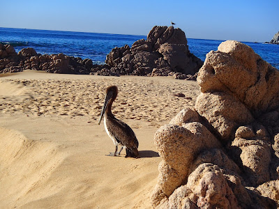
Wildlife in the Neighborhood

He was blocking my path!
Mexican Vultures??
Resident iguana
Live ones were too hard to photograph.
 Very Nice Golf Courses  (very expensive I might add!)

Todos Santos

Todos Santos is a small coastal village on the Pacific coast side of the Baja California peninsula, about an hours drive north of Cabo San Lucas.  The village was founded as a mission in 1724 and has become a haven for artists and craftsmen.  We rented a car one day to check it out.  The drive through the country side was very interesting.  I loved the fields and fields of saguaro cactus.

I would highly recommend having lunch at Tequila Sunrise.  The fish tacos were awesome and so was the service.  The owner was so welcoming and took such a good picture for me!


This nice merchant taught me that "It is better to live rich than die rich!"

Los Arcos

A visit to Cabo San Lucas MUST include a boat ride for an up close view of Los Arcos and Lover's Beach.  We chose OceanRiders for a zodiac fast boat snorkeling adventure.  It was great!  Check out their website at www.oceanriders.com.mx


Cabo San Lucas marina.

Beautiful Sunsets