Friday, April 25, 2014

Desolation Trail to the Salt Lake Overlook

The Desolation trail to the Salt Lake overlook is one of those great trails in Millcreek Canyon that can be repeated over and over and still be enjoyed each time.  The trailhead begins just east of the Millcreek Inn at the South Box Elder picnic area approximately 3 miles up Millcreek Canyon.  The hiking distance to the overlook rock is about 4.8 miles roundtrip with an elevation gain of 1250 feet.  The climb is gradual thanks to a series of easy switchbacks.  But best of all the hike is a lovely walk through a pine fragrant forest of fir and spruce.  The views are also pretty impressive.
 

I love this mossy area at the beginning of the trail which reminds me of a fairyland or the home of hobbits or leprechauns.  One mossy rock looked to have at least three different kinds of moss growing on the same rock.

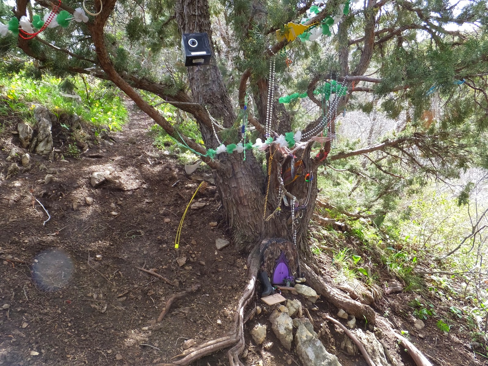
Speaking of fairy tales, a wrong turn on one of the switchbacks will bring you to this "fairy shrine".


After a brief stop at the overlook for pictures and a snack, my friend and I decided to explore a little further and continue following the trail towards upper Thayne Canyon.  We hiked for another half mile before the snow became more frequent and we decided we were finished for the afternoon.


This overturned tree root looked like some kind of scary animal from the before mentioned fairy tale.  We got spooked (because of the snow not the tree) and turned around at this point.  Plus my legs were getting tired.


♥ ♥ ♥ ♥ ♥ ♥ ♥ ♥ ♥ ♥ ♥ ♥ ♥ ♥ ♥ ♥ ♥


 Wildflower of the Week


This is a Glacier Lily, one of my all time favorite early spring wildflowers.  They are everywhere this time of year in the lower canyon areas.  Even though these lilies are found in abundance take the time to appreciate their delicate beauty.


For myself I hold no preferences among flowers
so long as they are wild, free, spontaneous!"
Ed Abbey

♥♥♥♥♥♥♥♥♥♥♥♥♥♥♥♥♥♥♥


******Miles hiked tally
beginning March 22, 2013
Beginning of this Blog


257.7

Monday, April 21, 2014

Mount Van Cott

Mount Van Cott is a small mountain (more of a knoll really) just east of the University of Utah which has the nickname of the "Butt Burner".   Mount Van Cott was named after Lucy May Van Cott who was the first dean of women at the University of Utah from 1907 to 1931.  I wonder if she was also a hiker?   There are many paths leading to the summit of Mount Van Cott.  I picked a trail heading north from Red Butte Canyon and just started climbing up.  For me, this Easter Sunday morning hike was just about immersing myself in nature to find a little peace.  And it worked by the way!  Here is some of what I saw along the way.
Don't know what these flowers are.

Magpie
Monarch Butterfly
Ladybug
Field of Springbeauties
University of Utah campus.
Kickin' down the mountain trail!
Sometimes when I'm hiking alone I create lyrics about hiking to popular songs (I'm weird, I know!), but here is a sample. . . . . . 

Slow down you move too fast, you want to make the hiking last.
Just kickin' down the mountain trail,
Looking at nature and feeling groovy!
Life, I love you!  All is groovy!!

Looking up at Mount Van Cott elevation 6348 feet.
The highlight of my hike was finding this handsome fella!  It is a horned lizard.  And he is really good at camouflage!
Horned Lizard
One of my favorite John Muir quotes was right on today "Nature's peace will flow into you as sunshine flows into trees".  I felt so much more peaceful at the end of hiking than I did at the beginning.

♥ ♥ ♥ ♥ ♥ ♥ ♥ ♥ ♥ ♥ ♥ ♥ ♥ ♥ ♥ ♥ ♥


 Wildflower of the Week


This wildflower is called a Tufted Evening Primrose.  It will open in the morning to become a beautiful, large, white flower but then closes and turns pink in the evening.  You will find the Tufted Evening Primrose on open sunny slopes during April, May and June.


For myself I hold no preferences among flowers
so long as they are wild, free, spontaneous!"
Ed Abbey

♥♥♥♥♥♥♥♥♥♥♥♥♥♥♥♥♥♥♥


******Miles hiked tally
beginning March 22, 2013
Beginning of this Blog


251.9

Wednesday, April 16, 2014

Mount Wire a.k.a Big Beacon

Spring is a great time to hike in the foothills above Salt Lake City.  Most of the snow is gone by this time of year on the low elevation peaks such as Mount Wire (elevation 7143 feet).  This is an excellent hike to begin conditioning for those higher peaks to climb in the summer.  Mount Wire has been described as a brown mound; but what this trail lacks in vegetation it more than makes up for in awesome views.  From the summit of Mt. Wire you look down into Emigration Canyon on one side and Red Butte Canyon on the other.  And the entire Salt Lake Valley to the point of the mountain is visible as well as Antelope Island and the Great Salt Lake.  I did mention that the views on this little mound were spectacular!
The trailhead is found above Research Park near the University of Utah.  Drive towards Red Butte Gardens and the new Museum of Natural History turning right on Colorow Drive and park alongside the road just before you reach the Huntsman Corp. building.  The trail begins on the left and will cross the Bonneville Shoreline trail before continuing to the right of Georges Hollow.  The popular "Living Room" hike is on the same trail.  You will reach a junction just shy of the one mile mark and the trail to Mt. Wire continues straight while the living room hike curves to the left.  The goal is to reach the old airway beacon which sets directly on the summit of Mount Wire.  There used to be two microwave radio reflectors also on the top of Mount Wire but they were removed last November.  The hike is 4.5 miles roundtrip with an elevation gain of 2140 feet.
Not quite there yet - false summit.


American Fork Twin Peaks in the far distance.
Old airway beacon - now we know we have almost made it!
Geodetic Marker

Adding a few feet of elevation
Mountain snail graveyard

First peak bagged of the year - Mount Wire!

♥ ♥ ♥ ♥ ♥ ♥ ♥ ♥ ♥ ♥ ♥ ♥ ♥ ♥ ♥ ♥ ♥


 Wildflower of the Week


This delicate little wildflower is a Wasatch Bluebell.  They are found scattered in the foothills this time of year and usher in the beginning of wildflower season.  Look close to the ground under the oaks or you may miss them.

"For myself I hold no preferences among flowers
so long as they are wild, free, spontaneous!"
Ed Abbey

♥♥♥♥♥♥♥♥♥♥♥♥♥♥♥♥♥♥♥


******Miles hiked tally
beginning March 22, 2013
Beginning of this Blog


248.8


Thursday, April 10, 2014

Searching for Cecret Lake

I know exactly how to find Cecret Lake in the summer!  Add 116 inches of snow depth and my favorite little lake gets swallowed up by Alta Ski Resort.  Cecret Lake sets at the base of Devil's Castle and Sugarloaf Peak - I know the landmarks well but getting to the lake yesterday proved to be a bit of a problem.
The plan was to follow the machine groomed cat tracks which we believed would lead straight to Cecret Lake, but there were too many cat tracks to choose from. And they all appeared to go towards our destination plus we needed to steer clear of the ski runs as much as possible.  We were wearing microspikes and yaktraks and carried missile sleds on our backpacks for a quick descent. (These sleds were so much fun!)  We probably could have used snowshoes on this hike.  Even though we didn't make it to Cecret Lake it was a beautiful day for hiking in the mountains and I got to explore Alta Ski Resort.  Our hike totaled 4.8 miles.
Heading towards Devil's Castle
Should have just followed the ski lift!  I'll hike this again with snowshoes.

Devil's Castle but no Cecret Lake.
Missile sleds away!  Last one to the bottom is a rotten egg! - Just having fun like a couple of kids!
 
These missile sleds were lightweight and with a couple of bungie cords attached to the backpack very easily.

 
I love the majestic views of Little Cottonwood Canyon
I found a wonderful hiking group to join called "Hike the Wasatch".  The group organizer plans weekly hikes all over the beautiful Wasatch mountains and beyond!  For a long time I resisted joining hiking groups because I mistakenly thought a group of people would ruin my hiking experience - not this group!  Here are a few of the benefits I discovered from hiking with this group.
  1. Learn new hiking techniques from experienced hikers.
  2. Learn about new hiking gear.
  3. Learn about new trails.
  4. Be inspired by what other hikers have accomplished.
  5. Share your passion for the outdoors with others.


♥♥♥♥♥♥♥♥♥♥♥♥♥♥♥♥♥♥♥


******Miles hiked tally
beginning March 22, 2013
Beginning of this Blog


251.2

Tuesday, April 1, 2014

Willow Heights Lake Again

I revisited Willow Heights Lake this week for another snowshoe hike. (The last time was in late November.)  We were the first ones on the trail today after Sunday's storm.  Snowshoeing through new snowfall is the best!  Yes, it is more challenging to break new trail, but what a great workout!  Even though I repeat the hike to Willow Heights Lake over and over, each time brings a new experience.  That is what I love about hiking, I never get bored.  There is always something new about the same old trail.  As I have mentioned previously Willow Heights Lake is a short, but steep trail.  We usually circle the lake to add a little more distance to our hike and still only hiked for 2.1 miles.  Love, love, love hiking through the thick quakies on this trail!


Back to the beginning of our hike . . . . .

Breaking new trail.
Today we found a dream catcher in a tree.  
A dream catcher is used so that only good dreams will be remembered.  The bad dreams will become hopelessly entangled in the web.  Native American folklore.

Back to the quakies . . . . .
Heading around the lake.
The trees have eyes and are watching you!
Willow Lake buried under a lot of snow!
The trail for Willow Heights Lake is found just past Silver Fork Lodge in Big Cottonwood Canyon.  Look for and park along the side of the road near this speed/curving road sign.


♥♥♥♥♥♥♥♥♥♥♥♥♥♥♥♥♥♥♥


******Miles hiked tally
beginning March 22, 2013
Beginning of this Blog


246.4