Thursday, June 12, 2014

Twin Lakes Pass

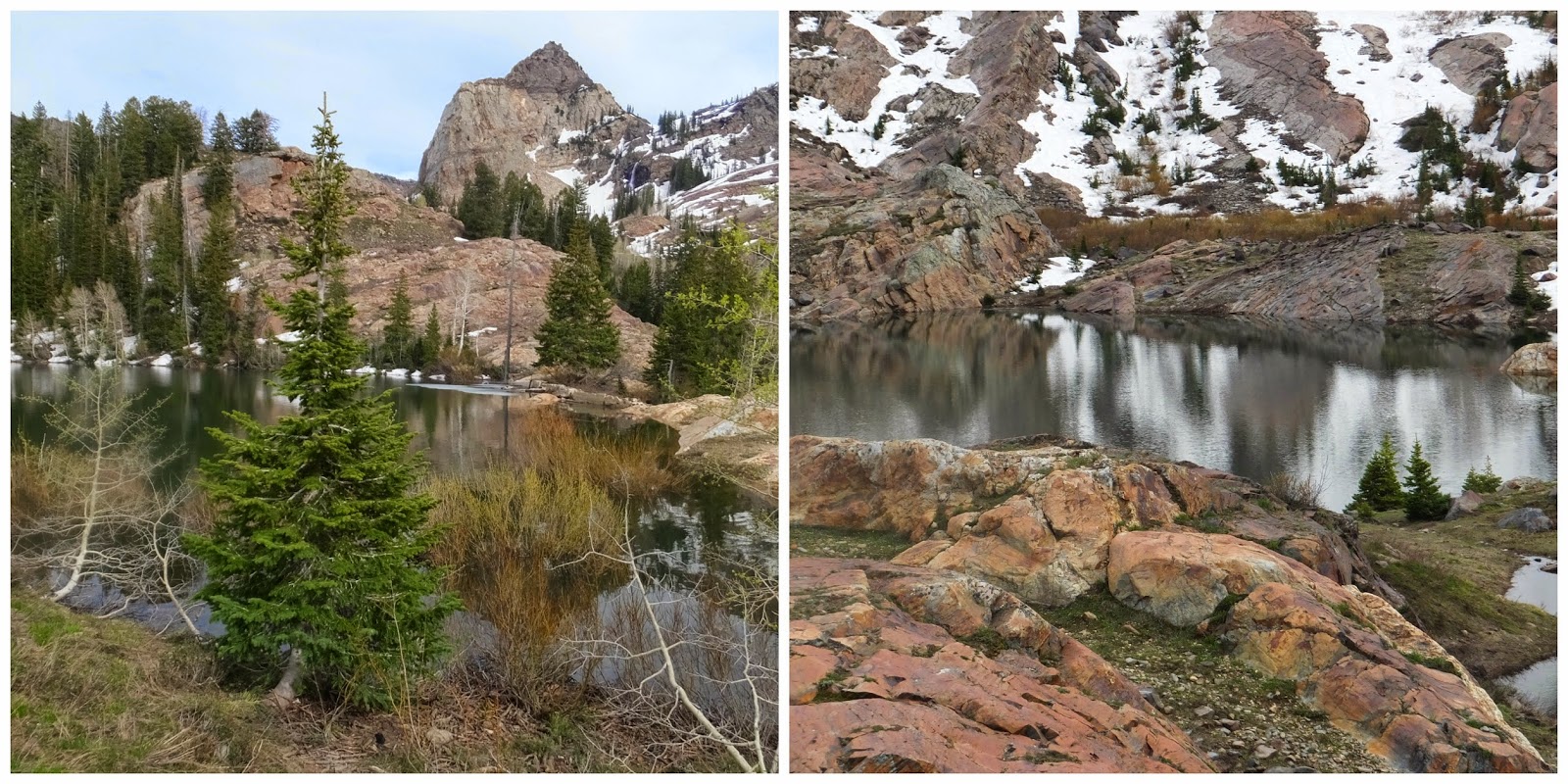
The trail to Twin Lakes Pass begins at lovely Silver Lake in Big Cottonwood Canyon.  About a quarter of the way around Silver Lake on the west side you will come to a junction with a trail sign for Twin Lakes and Lake Solitude -  Continue straight ahead.  The trail for Twin Lakes branches off to the left a few yards past this sign, then it is a steady uphill climb for one mile until you reach Twin Lakes dam.  Take time to soak in the views from Twin Lakes, it is a great hiking destination - but we are not finished yet!  Once you reach the Twin Lakes dam you will see a small trail on your right.  This trail will connect to a ski resort service road past Mount Evergreen.  At this point you could follow the service road down hill to Lake Solitude as a loop hike - but we are not finished yet!   The trail we we want continues up hill and was fairly easy to follow until we came upon a very large snow field.  We could see the footpath along the mountain and needed to cross the snow field to reach the notch in the ridge and hook up with the trail.  No big deal! and in another couple of weeks the snow will be gone and the trail more visible.  Soon you are looking down upon Twin Lakes and once you reach the pass you have awesome views down into Grizzly Gulch looking directly at Mount Superior and all the way down Little Cottonwood Canyon.  The pass sits at just under 10,000 feet.  Our hike totaled 4.5 miles roundtrip.  I enjoyed this hike immensely!!

Mount Superior from Twin Lakes Pass
I always get a little ahead of myself with this blog.  It is just that the end result is so amazing.  Back to the beginning . . . . . .
Trail to Twin Lakes dam just above Silver Lake
Twin pines on the way to Twin Lakes
Serene, tranquil, peaceful aspens
Mount Millicent on left, Wolverine Cirque on right and Twin Lakes below
Climbing the snow field
Mount Wolverine and the Wolverine Cirque
Geological Survey Marker and my good friend Martha
Nice view of the trail heading back

♥ ♥ ♥ ♥ ♥ ♥ ♥ ♥ ♥ ♥ ♥ ♥ ♥ ♥ ♥ ♥ ♥

 Wildflower of the Week


Mountain Bluebells are very easy to recognize!  This pretty wildflower covers the moist meadows and mountainsides in our canyons.  But did you know the flowers are edible raw and the plant has reported medicinal uses. (Don't ask me what the medicinal uses are, but that is what I read).  Mountain Bluebell plants sometimes grow to over three feet tall and have a very sweet fragrance.


For myself I hold no preferences among flowers
so long as they are wild, free, spontaneous!"
Ed Abbey

♥♥♥♥♥♥♥♥♥♥♥♥♥♥♥♥♥♥♥


******Miles hiked tally
beginning March 22, 2013
Beginning of this Blog
295.4


Monday, June 9, 2014

Hiking a Ghost Town, Mohrland, Utah

Mohrland, Utah was a booming mining community in the early 1920's with about 200 homes, a general store, a school, a hotel, an amusement hall and even a small hospital.  Now nature has reclaimed this area leaving only a glimpse of a bygone era with interesting history.  The mine was closed down and the town deserted in 1938.   Mohrland is now a ghost town located about eight miles north of Huntington, Utah (my childhood home) in Emery County near the base of Gentry Mountain.   It was fun hiking through the area looking at the remaining structures.  The stone building pictured below was believed to house explosives for the mine. It was located far from both the mine and homes in the area.
Pictured below is a foundation of one of the homes on what was known as silk stocking row.  This is where the more well to do families lived.  It was called silk stocking row because these were families that could afford to buy silk stockings.  Some of the homes were removed from their foundations and moved to nearby Huntington.  The home of my parents was one of these homes.


In 1917 one of Mohrland's residents, Edith Finley, brought from Wisconsin a Harrison yellow rosebush and planted it in her front yard.  Today that yellow rose still thrives and blooms among the sagebrush after all these years of neglect.  Tell me there are not ghosts (angels) that keep this beautiful rosebush alive.  My husband is 6'2" standing among the sagebrush that has reclaimed the area. 

Here is the foundation and all that remains of the school as well as a set of steps leading up to the school.  School is definitely out for the summer.
The company store was opened in 1910 and called the Wasatch Store.  Competing merchants were not allowed in town.  Now I understand the meaning of the lyrics "I owe my soul to the company store" from the song Sixteen Tons by Tennessee Ernie Ford singing about the life of a coal miner.   All that remains is the part of the building where the safe for keeping money was stored.


 Now on to the coal mine . . . . .

The only structure left at the mine entrance is the repair shop or blacksmith shop.  The stone work has held up well over the years.
Special thanks to Lori Ann Larsen and my father Vernell Rowley for being excellant hiking guides and compiling such a great history of Mohrland, Utah.  I will definitely go back and explore again!!

♥ ♥ ♥ ♥ ♥ ♥ ♥ ♥ ♥ ♥ ♥ ♥ ♥ ♥ ♥ ♥ ♥

 Wildflower of the Week


This wildflower is a Prickly Poppy and is found alongside country roads all over southern Utah especially in the Pinyon and Juniper areas.  Prickly Poppies have very large, brilliantly white blossoms which look delicate and lovely from a distance.  But it is a scarey looking plant up close with thorny spines that would prevent anyone from trying to pick one!  The bright reddish-purple center isn't a bug it is the plants stigma.

For myself I hold no preferences among flowers
so long as they are wild, free, spontaneous!"
Ed Abbey

♥♥♥♥♥♥♥♥♥♥♥♥♥♥♥♥♥♥♥


******Miles hiked tally
beginning March 22, 2013
Beginning of this Blog
290.9


Thursday, June 5, 2014

Lambs Canyon Trail

Although Lambs Canyon is some what removed from the major canyons in our area, it has a very nice trail to hike and is really only minutes from Salt Lake City.   Take I-80 East through Parleys Canyon and exit at Lambs Canyon #137.  The trailhead is found about 1.6 miles from the freeway off ramp along a narrow, winding road.  There is a restroom and a very small parking area (enough space for 4 or 5 cars) directly across the road from the trailhead. The trail climbs through fir, aspen and lush foliage following a small stream which hides from view in spots (heard but not seen) - very lovely.   After about 2.2 miles you will reach the saddle which is the Millcreek Ridge or Lambs Canyon Pass at 8,150 feet.  The elevation gain on this hike is 1560 feet, steep but not too steep.  The trail from Lambs Canyon is the only Forest Service hiking trail on the Parleys Canyon side of the ridge and they have recently done some trail maintenance which was nice to see. 
Small stream - watch out for snakes.
The Lambs Canyon trail at the saddle connects with the Elbow Fork trail coming up from Millcreek Canyon.  Both Lambs Canyon trail and Elbow Fork trail are part of the Great Western Trail system.  Today we ventured above and beyond Lambs Canyon pass to a radio tower that sits on the peak just east of the main trail.  There is a small trail just past the old Lambs Canyon sign heading left from the junction - look closely or you may miss it.
Sign at the pass.


It was only an additional 1.4 miles roundtrip and an additional 710 feet of elevation to visit the radio tower, but I didn't love the trail.  It felt a little like bushwhacking and our legs got pretty scratched.  Okay, I'll admit it was interesting and the views were awesome.  Best trail description however is told through pictures.  Here are some of my best.


Nice view of Grandeur Peak on the right.

Looking towards the Great Salt Lake and Antelope Island.
First glimpse of the radio tower on the peak.
Close up of the radio tower.
Delivered by helicopter.
From the radio tower peak looking at Gobblers Knob.
Another mountain peak?
Heading back down the trail from radio tower.
The blue clematis were everywhere!

♥ ♥ ♥ ♥ ♥ ♥ ♥ ♥ ♥ ♥ ♥ ♥ ♥ ♥ ♥ ♥ ♥

 Wildflower of the Week


This mountain plant is called a Baneberry.  Not sure it qualifies as a wildflower, but the white plumes were striking and so are the bright red berries the plant produces in the fall.  Come to find out this plant is extremely toxic.  All parts are poisonous! especially the roots and berries.  The Baneberry bushes were thick on the Lambs Canyon trail.  

For myself I hold no preferences among flowers
so long as they are wild, free, spontaneous!"
Ed Abbey

♥♥♥♥♥♥♥♥♥♥♥♥♥♥♥♥♥♥♥


******Miles hiked tally
beginning March 22, 2013
Beginning of this Blog
287.9


Sunday, June 1, 2014

Lake Blanche and Beyond

The hike to Lake Blanche is a pretty strenuous one in my book, but the unique scenic beauty of this area make the trip more than worth the effort.  No wonder it is so popular and probably the most hiked trail in Big Cottonwood Canyon.  This time up we explored the sister lakes of Florence and Lillian.  Again . . .  absolutely beautiful!   These lakes sit in a high alpine basin created by a huge glacier about a million years ago - a geological treasure!  The rocks that surround the lakes are beautifully etched with long marks and smooth grooves as evidence of this glacier activity.  And then there is Sundial Peak at the center of this masterpiece!  With water cascading from its heights into Lake Blanche!  It is the scene from an epic tale.  A little dramatic I know, but tell me that's not pretty impressive!
In the early 1900's dams were built at each lake to create and maintain an abundant supply of water for the dry Salt Lake valley.  These dams have long since crumpled and burst with just the walls remaining and now the water flows from Lake Blanche into Lake Florence, from Lake Florence into Lake Lillian and from Lake Lillian down the canyon until it meets up with Big Cottonwood creek.  Today that water was raging!  

I took a lot of pictures!  Here are some of the best.
 Sundial Peak
So many really cool rocks.  A geologists paradise!
Plantain Buttercups everywhere.
More of Lake Blanche from the west end showing what remains of the 1930's dam with Dromedary Peak in the background and a really nice shot of the reflection of Sundial Peak on the lake.

Now on to Lake Florence.  There is a really beautiful waterfall pouring into Lake Florence from Lake Blanche.  Sundial Peak looks a lot different from this angle.

Last but not least is Lake Lillian.  Another picture of the water flowing from Lake Florence into Lake Lillian, the 1930s dam and also of Sundial Peak from Lake Lillian perspective.


Looking back down canyon from Lake Blanche
We hiked today (May 29, 2014) for 7.7 miles with an elevation gain of around 2700 feet.  I think the key to enjoying this hike is to give yourself plenty of time.  Take many breaks going up AND coming down.  And of course spend time at each lake!  Make an entire day of it if you can.
 
♥ ♥ ♥ ♥ ♥ ♥ ♥ ♥ ♥ ♥ ♥ ♥ ♥ ♥ ♥ ♥ ♥

 Wildflower of the Week


This interesting wildflower is called a Clematis.  It reminds you of a lavender colored paper lantern.  It is a vine plant that climbs into the surround shrubs.  When a Clematis turns to seed it forms long plumes that look like a white stringy "hippy-head".


For myself I hold no preferences among flowers
so long as they are wild, free, spontaneous!"
Ed Abbey

♥♥♥♥♥♥♥♥♥♥♥♥♥♥♥♥♥♥♥


******Miles hiked tally
beginning March 22, 2013
Beginning of this Blog


282.1