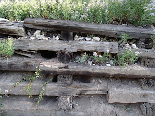
 My little spontaneous hike Sunday morning took me to the top of Mount Evergreen. Mount Evergreen is the forested ridge directly north of Twin Lakes in the heart of Brighton Ski Resort. Once you reach Twin Lakes dam you will find a trail on your right which takes you above the lakes and eventually joins one of the ski resorts service roads passing along an old retaining wall built with railroad ties (see picture below). The old road takes you to a saddle which is Mill F South Fork. From this point you can continue straight ahead for Twin Lakes Pass or stay on the service road to the right and drop down to Lake Solitude which makes a nice loop hike. And that's exactly what I did with a little detour to climb up Evergreen Peak (9,840). All I had to do was
 follow the ski lift sign pointing up. I seriously can't believe anyone would ski this! A double black diamond!! It doesn't look daunting until you start to climb up and even worse climbing back down. But that's what I did. Go ahead, call me craZy! The path reminded me of Angels Landing in Zion National Park. Very steep cliffs on both sides but without chains to hold on to. I won't repeat climbing Mount Evergreen.
 |
| NO KIDDING!! |
 |
| Steep drops on both sides. |
Pennies were tossed into the hollow of this old spruce tree. For good luck I suppose. I didn't have a penny to contribute, darn.
Mount Evergreen gets its name from the Englemann Spruces that crown the summit. Some of the spruces were old and gnarled yet really beautiful in my opinion.
You do have beautiful views of Twin Lakes, Mount Millicent and Mount Wolverine from this height.
This is looking down on Lake Solitude from the service road as I completed the loop hike.
The old retaining wall built with railroad ties mentioned above. The total loop hike, Twin Lakes to Lake Solitude was approximately 3 miles with an elevation gain of about 1000 feet.
♥♥♥♥♥♥♥♥♥♥♥♥♥♥♥♥♥♥♥♥♥
"For myself I hold no preferences
among flowers so long as they are
wild, free, spontaneous!" Ed Abbey
Wildflower of the Week
This
wildflower is called a Showy Daisy. It is bright purple with dark yellow centers and grows abundantly in the canyons and mountains of the Wasatch. Showy Daisies have a very long blooming season so when all other wildflowers are gone you will still see these cheerful wildflowers.
♦♦♦♦♦♦♦♦♦♦♦♦♦♦♦♦♦♦♦♦♦
Peaks Bagged
1. Grandeur Peak ♦♦ 8299
2. Reynolds Peak ♦♦ 9422
3. South Guardsman Pass Peak ♦♦ 10,420
4. Mount Baldy ♦♦ 11,068
5. Mount Evergreen ♦♦ 9,840
******Miles hiked tally
beginning March 22, 2013
102.5


